
Dubai Metro Blue Line Map Reveals 14 New Stations
Dubai’s expanding metro system just reached a new milestone. The Roads and Transport Authority unveiled the Dubai Metro Blue Line Map and confirmed it will add 14 new stations by 2029. With nearly equal sections above and below ground, the Blue Line will transform daily travel for thousands of residents.
The project will also help ease road congestion and boost property values in connected areas. Dubai Ruler Sheikh Mohammed bin Rashid Al Maktoum laid the foundation stone in June. The first iconic station design has already been unveiled.
View the official Dubai Metro Blue Line route map as shared by RTA below:
إليك خريطة مسار الخط الأزرق لـ #مترو_دبي، من #هيئة_الطرق_و_المواصلات، المشروع الذي سيربط عند افتتاحه عام 2029، بين 14 محطة هامة حول دبي، بينها محطات علوية ومحطات تحت مستوى الأرض، بقدرة استيعابية تتجاوز 350 ألف راكب يومياً. يساهم المشروع في تحقيق أعلى تكامل لشبكة المترو، إلى جانب… pic.twitter.com/16ZBxU83Md
— RTA (@rta_dubai) December 14, 2025
Elevated and Underground Stations Explained
The Dubai Metro Blue Line Map includes 14 stations. There will be 5 elevated stations, 4 underground stations, 4 future elevated stations, and one major underground interchange station.
The route will stretch across 30 kilometers, with 14.5 kilometers running above ground and 15.5 kilometers underground. The line will carry over 320,000 passengers daily once completed. By November 2025, 10 % of the construction work was completed in just five months.
14 stations total:
- 5 elevated
- 4 underground
- 4 future elevated
- 1 underground interchange
Track length: 14.5 km above ground, 15.5 km underground
Passenger capacity: Over 320,000 daily
Progress: 10% completed in just 5 months (as of Nov 2025)
Two Routes, One Network
The Blue Line has two main routes.
- The first starts at Creek Station on the Green Line and passes through Dubai Festival City, Dubai Creek Harbour, Ras Al Khor, and International City 1. This route includes the main interchange station. From there, it continues through International City 2 and 3, Dubai Silicon Oasis, and ends at Academic City.
- The second route connects Centrepoint Station on the Red Line to International City 1. It passes through Mirdif and Al Warqa, creating vital links between eastern communities and the rest of the network.
Together, the routes integrate Dubai’s Red and Green Lines while serving high-density residential zones.
Route 1: Green Line to Academic City
Start: Creek Station
Stops: Festival City → Creek Harbour → Ras Al Khor → Int’l City 1
Continues: Int’l City 2 → Int’l City 3 → Silicon Oasis → Academic City
Route 2: Red Line to Interchange
Start: Centrepoint Station
Stops: Mirdif → Al Warqa → Ends at Int’l City 1 (interchange)
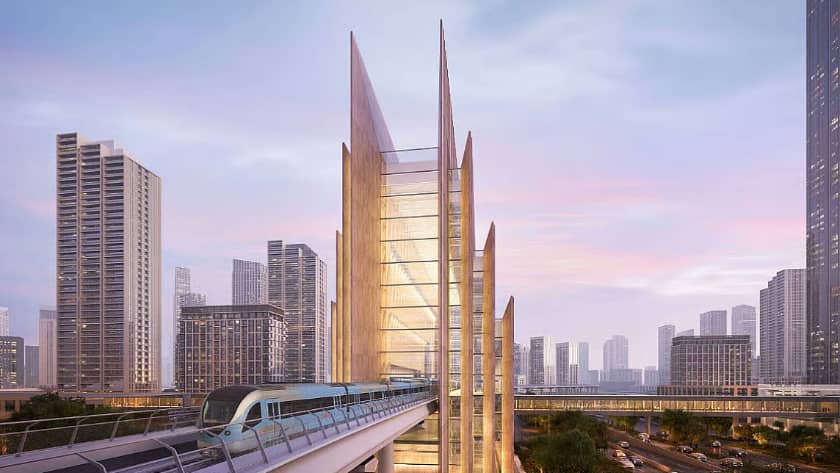
Iconic Station Design and Community Impact
The design of elevated stations draws inspiration from seashells. Interiors follow themes of earth, air, water, fire, and heritage. The first revealed station, named after Emaar Properties, stands 74 meters tall. It features three levels and will become the world’s highest metro station.
Designed by Skidmore, Owings & Merrill, the same firm behind the Burj Khalifa, the station blends modern glass panels with traditional metro arches. Communities along the Blue Line are already seeing change. Rents are rising in areas close to the new route.
Road diversions are in place, showing fast progress across construction zones. The line is expected to reduce traffic by 20% and serve over 50,000 university students from Academic City.
Conclusion
The release of the Dubai Metro Blue Line Map signals a big leap forward for urban mobility in the UAE. With new routes, advanced station designs, and increased capacity, the Blue Line Metro is set to reshape how people move across the city.
Excited about where this line will take Dubai next? Share your thoughts in the comments. For the latest UAE transport news, stay tuned to the Arabwheels Blog.